In Brief (TL;DR)
The UK prepares for volatile weather as opposing systems clash, triggering warnings for severe storms and flooding.
Meteorologists predict a drastic shift to freezing conditions with potential widespread snowfall affecting the country by late January.
Regional alerts highlight disruption risks while experts link these unpredictable patterns to broader global climate volatility.
The devil is in the details. 👇 Keep reading to discover the critical steps and practical tips to avoid mistakes.
As of Monday, January 19, 2026, the United Kingdom is bracing for a significant shift in weather conditions, prompting a surge of interest in the latest Met Office forecasts. With over 5,000 searches trending for "snow weather forecast met office," Britons are preparing for what meteorologists are describing as a "battle" between opposing weather systems. The Met Office has issued alerts indicating that while milder Atlantic air is currently dominating, a transition to much colder, wintry conditions is imminent, bringing the potential for snow, ice, and severe storms to various parts of the country.
According to the latest reports from the Met Office and BBC Weather, the UK is currently sandwiched between high pressure to the north and low-pressure systems from the Atlantic. This meteorological standoff is expected to result in a volatile week of weather, starting with heavy rain and strong winds before giving way to a freezing snap that could see snow accumulating in the northeast and potentially spreading further south by the end of the month. The situation highlights the increasing unpredictability of winter weather patterns, a subject of growing concern within the climate science community.

The ‘Battle’ of Weather Systems
The Met Office has characterized the current forecast as a "battleground" scenario. According to a spokesperson for the agency, the UK is caught between "Atlantic weather systems attempting to push in from the west" and "high pressure and colder, drier conditions" trying to exert influence from the east. Initially, the Atlantic influence will bring wet and windy weather, particularly to the north and west of the UK.
Specific warnings have already been issued. A yellow weather warning for rain is in place for parts of Scotland from Wednesday, January 21, through Friday, January 23, with the potential for over 100mm of rainfall in some areas. Additionally, a yellow warning for wind covers parts of southwest England and Wales for Tuesday, January 20. These systems are expected to bring disruption to travel and potential flooding, underscoring the severity of the incoming unsettled conditions.
Snow Forecast and the ‘Purple Alert’
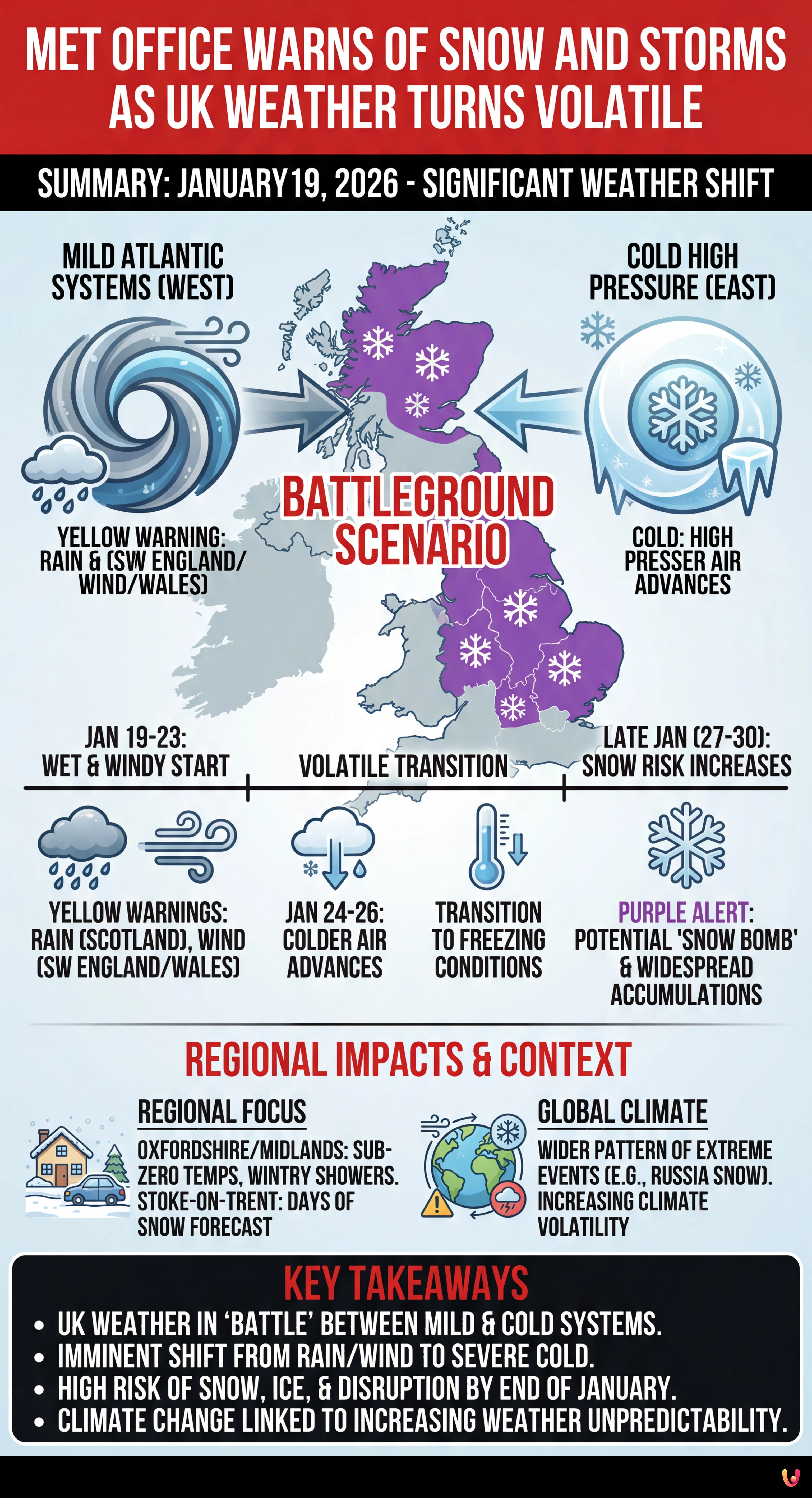
While rain dominates the immediate forecast for the south, the prospect of snow is the primary driver of public concern. The Met Office has confirmed that colder air is likely to win the "battle" later in the week and into the final days of January. The forecast indicates that the far northeast of the UK, particularly the Scottish Highlands, will see sleet and snow as early as this weekend. However, the concern for widespread snowfall increases towards the end of the month.
According to data cited by Birmingham Live and other outlets, weather maps have turned purple—indicating snow—for late January. Some models, including those from WX Charts, suggest a "snow bomb" could impact the UK around January 27 or 30, potentially dumping significant accumulations of snow. The BBC Weather team has supported this outlook, stating that a "colder-than-average period is most probable" as we head into February, with an increased chance of wintry hazards affecting even lower levels in the south.
Regional Impacts: Oxfordshire and the Midlands

The impact of this cold shift is being closely monitored at a regional level. The Oxford Mail reports that Oxfordshire and surrounding areas are preparing for temperatures to drop significantly. While the county has seen milder conditions recently, forecasts predict a return to sub-zero overnight temperatures. Local reports indicate that while the heaviest snow is predicted for the north, the Midlands and the southeast could experience wintry showers and icy conditions as the cold front advances.
In Stoke-on-Trent and Staffordshire, BBC meteorologists have forecasted "days of snow" starting from January 26, with sleet and light snow flurries expected to persist through the end of the month. This aligns with the broader national picture of a country facing a prolonged period of winter severity, necessitating caution for commuters and vulnerable residents.
Global Climate Context
The severe weather threatening the UK is part of a wider pattern of extreme winter events observed globally in early 2026. Sky News has reported on a "snow apocalypse" in Russia’s Kamchatka Peninsula, where towns have been buried under more than seven feet of snow, paralyzing transportation and forcing a state of emergency. While the UK is not expecting snowfall of that magnitude, the simultaneous occurrence of such extreme weather events serves as a stark reminder of the intensifying volatility of the global climate system.
Climate scientists continue to warn that as global temperatures rise, the jet stream can become more erratic, leading to prolonged blocking patterns that lock in extreme cold or wet weather for extended periods. The current "battle" over the UK is a prime example of these complex atmospheric interactions, which are becoming more frequent and severe.
Conclusion

As January 2026 progresses, the UK stands on the precipice of a significant winter weather event. The Met Office’s forecast of a clash between Atlantic storms and continental cold air promises a week of heavy rain and gales, followed by a high probability of snow and freezing temperatures. With warnings already in place and long-range models predicting a potential "snow bomb" for late January, the public is urged to remain vigilant. Keeping up to date with the latest forecasts from the Met Office and local news sources will be essential as the country navigates this period of serious and changeable weather.
Frequently Asked Questions

According to the latest forecasts, snow is expected to arrive in two phases. The Scottish Highlands may see sleet and snow as early as the weekend following January 19. However, widespread snowfall is more likely towards the end of the month, with weather models indicating a potential cold snap or snow bomb around January 27 to 30 that could affect the Midlands and potentially spread to southern England.
The Met Office has issued yellow weather warnings for specific regions due to incoming Atlantic storms. These include a warning for strong winds covering parts of southwest England and Wales for Tuesday, January 20. Additionally, a warning for heavy rain is in place for parts of Scotland from Wednesday, January 21, through Friday, January 23, which brings a risk of flooding and travel disruption.
Yes, a significant drop in temperature is imminent. While the week begins with milder Atlantic air bringing rain and wind, meteorologists predict a transition to much colder conditions as high pressure exerts influence. By the end of January, freezing temperatures are expected to dominate, leading to a colder-than-average period as the country heads into February.
Current weather maps suggest that the far northeast of the UK will experience the initial wintry conditions. However, as the cold front advances, the risk of snow extends to the Midlands and the southeast. Places like Stoke-on-Trent and Staffordshire are forecasted to see days of snow starting from January 26, while lower levels in the south may experience wintry hazards and icy conditions.
Meteorologists use the term battleground to describe the current clash between two opposing weather systems. The UK is currently sandwiched between mild, wet Atlantic low-pressure systems pushing from the west and cold, dry high-pressure systems from the east. This atmospheric standoff creates volatile conditions, resulting in a mix of heavy rain, gales, and an eventual shift to freezing winter weather.
Sources and Further Reading


Did you find this article helpful? Is there another topic you'd like to see me cover?
Write it in the comments below! I take inspiration directly from your suggestions.